
Takk for at du støtter denne siden ❤️
Gi en donasjon
Gi en donasjon
Topografisk kart Adilabad
Klikk på kartet for å vise høyde.
Takk for at du støtter denne siden ❤️
Gi en donasjon
Gi en donasjon
Adilabad
Adilabad has an average elevation of 264 metres. The district shares its boundaries with Nirmal districts of Telangana to the south, Komaram Bheem district on the east, with Nanded on the west and Yavatmal and Chandrapur districts of Maharashtra to the north.
Takk for at du støtter denne siden ❤️
Gi en donasjon
Gi en donasjon
Om dette kartet
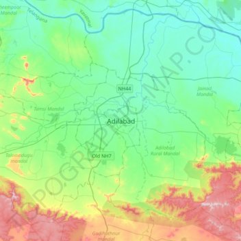
Navn: Topografisk kort Adilabad, højde, relief.
Gjennomsnittlig høyde: 310 m
Minste høyde: 196 m
Maksimal høyde: 626 m
Takk for at du støtter denne siden ❤️
Gi en donasjon
Gi en donasjon