
Gi en donasjon
Topografisk kart Enchanted Rock
Klikk på kartet for å vise høyde.
Gi en donasjon
Enchanted Rock
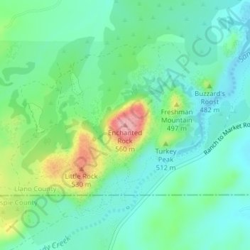
Enchanted Rock is a pink granite mountain located in the Llano Uplift about 17 miles (27 km) north of Fredericksburg, Texas and 24 miles (39 km) south of Llano, Texas, United States. Enchanted Rock State Natural Area, which includes Enchanted Rock and surrounding land, spans the border between Gillespie and Llano counties, south of the Llano River. Enchanted Rock covers roughly 640 acres (260 ha) and rises around 425 feet (130 m) above the surrounding terrain to an elevation of 1,825 feet (556 m) above sea level. It is the largest pink granite monadnock in the United States. Enchanted Rock State Natural Area, a part of the Texas state park system, includes 1,644 acres (665 ha). In 1936, the area was designated a Recorded Texas Historic Landmark. In 1971, Enchanted Rock was designated as a National Natural Landmark by the National Park Service.
Gi en donasjon
Om dette kartet
Navn: Topografisk kort Enchanted Rock, højde, relief.
Sted: Enchanted Rock, Llano County, Texas, United States (30.50642 -98.81885 30.50652 -98.81875)
Gjennomsnittlig høyde: 453 m
Minste høyde: 414 m
Maksimal høyde: 554 m
Gi en donasjon
Andre topografiske kart
Klikk på et kart for å se dets topografi, dets høyde og dets relieff.