
Gi en donasjon
Topografisk kart South Fulton
Klikk på kartet for å vise høyde.
Gi en donasjon
Om dette kartet
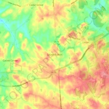
Navn: Topografisk kort South Fulton, højde, relief.
Sted: South Fulton, Fulton County, Georgia, United States (33.55027 -84.71123 33.63027 -84.63123)
Gjennomsnittlig høyde: 272 m
Minste høyde: 220 m
Maksimal høyde: 319 m
Gi en donasjon
Andre topografiske kart
Klikk på et kart for å se dets topografi, dets høyde og dets relieff.
Atlanta
United States > Georgia > Fulton County
Atlanta features a varied topography characterized by its rolling hills and elevated terrain. The city sits at an average elevation of approximately 1,050 feet (320 meters) above sea level, with elevations ranging from about 725 feet (221 meters) to 1,175 feet (358 meters) in the surrounding areas. This…
Gjennomsnittlig høyde: 284 m
Milton
United States > Georgia > Fulton County
According to the U.S. Census Bureau, the city of Milton has a total area of 39.2 square miles (101.4 km2), of which 38.5 square miles (99.8 km2) is land and 0.62 square miles (1.6 km2), or 1.59%, is water. The elevation ranges from 950 to 1,280 feet (290 to 390 m) above sea level.
Gjennomsnittlig høyde: 330 m
Gi en donasjon
Johns Creek
United States > Georgia > Fulton County
Johns Creek is located in northeastern Fulton County and is centered at 34°1′44″N 84°11′55″W / 34.02889°N 84.19861°W / 34.02889; -84.19861 (34.0289259, -84.1985790). The elevation ranges from 880 feet (270 m) above sea level along the Chattahoochee River to 1,180 feet (360 m) in the Ocee…
Gjennomsnittlig høyde: 314 m
Atlanta
United States > Georgia > Fulton County
Atlanta (/ætˈlæntə/ at-LAN-tə, or /ætˈlænə/ at-LAN-ə) is the capital and most populous city of the U.S. state of Georgia. It is the seat of Fulton County, although a portion of the city extends into neighboring DeKalb County. With a population of 498,715 living within the city limits, Atlanta is the…
Gjennomsnittlig høyde: 284 m
Atlanta
United States > Georgia > Fulton County
Atlanta (/ætˈlæn(t)ə/ at-LAN-(t)ə) is the capital and most populous city in the U.S. state of Georgia. It is the seat of Fulton County, and a portion of the city extends into neighboring DeKalb County. While not included in city limits, unincorporated areas that carry an Atlanta address spill into…
Gjennomsnittlig høyde: 284 m
Gi en donasjon
Atlanta
United States > Georgia > Fulton County
Atlanta (/ætˈlæntə/ at-LAN-tə) is the capital and most populous city of the U.S. state of Georgia. It is the seat of Fulton County, the most populous county in Georgia, although a portion of the city extends into neighboring DeKalb county. With a population of 498,715 living within the city limits, it is…
Gjennomsnittlig høyde: 284 m
Gi en donasjon
Milton
United States > Georgia > Fulton County
According to the U.S. Census Bureau, the city of Milton has a total area of 39.2 square miles (101.4 km2), of which 38.5 square miles (99.8 km2) is land and 0.62 square miles (1.6 km2), or 1.59%, is water. The elevation ranges from 950 to 1,280 feet (290 to 390 m) above sea level.
Gjennomsnittlig høyde: 330 m
Gi en donasjon
Atlanta
United States > Georgia > Fulton County
Atlanta (/ætˈlæntə/ at-LAN-tə) is the capital and most populous city in the U.S. state of Georgia. It is the seat of Fulton County, and a portion of the city extends into neighboring DeKalb County. With a population of 510,823 (2023 estimate) living within the city limits, Atlanta is the eighth most…
Gjennomsnittlig høyde: 284 m
Johns Creek
United States > Georgia > Fulton County
Johns Creek is located in northeastern Fulton County. The elevation ranges from 880 feet (270 m) above sea level along the Chattahoochee River to 1,180 feet (360 m) in the Ocee area along the Alpharetta border. Johns Creek is bounded to the south by the Chattahoochee River and Gwinnett County, and on the…
Gjennomsnittlig høyde: 314 m
Gi en donasjon
Atlanta
United States > Georgia > Fulton County
Atlanta (/ætˈlæn(t)ə/ at-LAN-(t)ə) is the capital and most populous city in the U.S. state of Georgia. It is the seat of Fulton County, and a portion of the city extends into neighboring DeKalb County. With a population of 498,715 living within the city limits, Atlanta is the eighth most populous city in…
Gjennomsnittlig høyde: 284 m
Gi en donasjon
Atlanta
United States > Georgia > Fulton County
Atlanta (/ætˈlæntə/ at-LAN-tə) is the capital and most populous city in the U.S. state of Georgia. It is the seat of Fulton County, and a portion of the city extends into neighboring DeKalb County. With a population of 510,823 living within the city limits, Atlanta is the eighth most populous city in the…
Gjennomsnittlig høyde: 284 m
Gi en donasjon
Gi en donasjon
Gi en donasjon
Milton
United States > Georgia > Fulton County
According to the U.S. Census Bureau, the city of Milton has a total area of 39.2 square miles (101.4 km2), of which 38.5 square miles (99.8 km2) is land and 0.62 square miles (1.6 km2), or 1.59%, is water. The elevation ranges from 950 to 1,280 feet (290 to 390 m) above sea level.
Gjennomsnittlig høyde: 330 m
Gi en donasjon