Geolokaliser

Topografisk kart Kung Man Village

Klikk på kartet for å vise høyde.

Om dette kartet

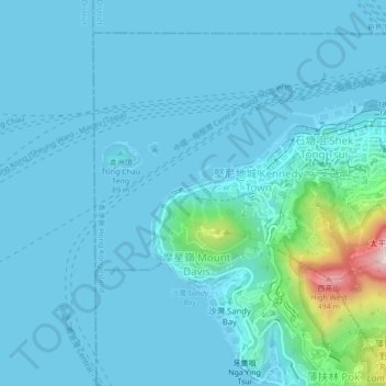
Navn: Topografisk kort Kung Man Village, højde, relief.

Sted: Kung Man Village, Central and Western District, Hong Kong Island, Hong Kong, 999077, China (22.26093 114.10107 22.30093 114.14107)

Gjennomsnittlig høyde: 46 m

Minste høyde: -1 m

Maksimal høyde: 488 m

Andre topografiske kart

Klikk på et kart for å se dets topografi, dets høyde og dets relieff.

Ap Lei Chau

China > Hong Kong > Hong Kong Island

Gjennomsnittlig høyde: 25 m

Cheung Kong Park

China > Hong Kong > Hong Kong Island

Gjennomsnittlig høyde: 132 m

Southern District

China > Hong Kong > Hong Kong Island

Gjennomsnittlig høyde: 36 m

The Twins

China > Hong Kong > Hong Kong Island

Gjennomsnittlig høyde: 99 m

The Twins

China > Hong Kong > Hong Kong Island

Gjennomsnittlig høyde: 99 m

Round Island

China > Hong Kong > Hong Kong Island

Gjennomsnittlig høyde: 3 m

Pok Fu Lam Reservoir

China > Hong Kong > Hong Kong Island

Gjennomsnittlig høyde: 192 m