
Gi en donasjon
Topografisk kart Langar
Klikk på kartet for å vise høyde.
Gi en donasjon
Om dette kartet
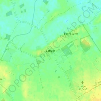
Navn: Topografisk kort Langar, højde, relief.
Gjennomsnittlig høyde: 32 m
Minste høyde: 23 m
Maksimal høyde: 43 m
Gi en donasjon
Andre topografiske kart
Klikk på et kart for å se dets topografi, dets høyde og dets relieff.
Barton in Fabis
United Kingdom > England > Nottinghamshire > Rushcliffe > Barton-in-Fabis
Gjennomsnittlig høyde: 39 m
Normanton on the Wolds
United Kingdom > England > Nottinghamshire > Rushcliffe
Gjennomsnittlig høyde: 59 m
Gi en donasjon
Gi en donasjon
Willoughby on the Wolds
United Kingdom > England > Nottinghamshire > Rushcliffe
Gjennomsnittlig høyde: 92 m
Gi en donasjon
Archers Lake
United Kingdom > England > Nottinghamshire > Rushcliffe > Bingham
Gjennomsnittlig høyde: 28 m
Gi en donasjon
Gi en donasjon
Elton-on-the-Hill
United Kingdom > England > Nottinghamshire > Rushcliffe
Elton lies about 14 miles (23 km) east of Nottingham. It straddles the A52 trunk road, from which Station Road runs north towards Orston and Sutton Lane south, with Sutton-cum-Granby being the nearest hamlet in that direction. Elton has a population of 114 people and is in the Rushcliffe district. It has an…
Gjennomsnittlig høyde: 29 m
Clipston
United Kingdom > England > Nottinghamshire > Rushcliffe
Clipston stands on the northernmost edge of the Wolds in Nottinghamshire. The area enjoys, from an elevation of about 79 m/259 ft, panoramic views of the Trent valley and the East and South side of the city of Nottingham, some 50 m/164 ft lower. Nearby to the west is Hoe Hill, with a horseshoe-shaped wood.
Gjennomsnittlig høyde: 59 m
Gi en donasjon
Flintham
United Kingdom > England > Nottinghamshire > Rushcliffe > Flintham
Gjennomsnittlig høyde: 37 m
Gi en donasjon
Gi en donasjon
Colston Bassett
United Kingdom > England > Nottinghamshire > Rushcliffe > Colston Bassett
Gjennomsnittlig høyde: 39 m
Gi en donasjon
Radcliffe on Trent
United Kingdom > England > Nottinghamshire > Rushcliffe
Gjennomsnittlig høyde: 37 m