
Takk for at du støtter denne siden ❤️
Gi en donasjon
Gi en donasjon
Topografisk kart Ben Hur
Klikk på kartet for å vise høyde.
Takk for at du støtter denne siden ❤️
Gi en donasjon
Gi en donasjon
Om dette kartet
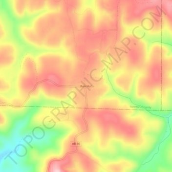
Navn: Topografisk kort Ben Hur, højde, relief.
Sted: Ben Hur, Newton County, Arkansas, United States (35.71036 -92.99295 35.75036 -92.95295)
Gjennomsnittlig høyde: 501 m
Minste høyde: 376 m
Maksimal høyde: 583 m
Takk for at du støtter denne siden ❤️
Gi en donasjon
Gi en donasjon
Andre topografiske kart
Klikk på et kart for å se dets topografi, dets høyde og dets relieff.
Buffalo National River
United States > Arkansas > Newton County
Along the upper river, the gradient is steep and the water is fast, leveling and slowing as the river runs its course. The upper section has most of the whitewater rapids to be found along the river, and features dramatic karst topography including sink holes and caves, springs, and waterfalls, over 500-foot…
Gjennomsnittlig høyde: 444 m
Takk for at du støtter denne siden ❤️
Gi en donasjon
Gi en donasjon