
Gi en donasjon
Topografisk kart New Orleans
Klikk på kartet for å vise høyde.
Gi en donasjon
New Orleans
Founded in 1718 by French colonists, New Orleans was once the territorial capital of French Louisiana before becoming part of the United States in the Louisiana Purchase of 1803. New Orleans in 1840 was the third most populous city in the United States, and it was the largest city in the American South from the Antebellum era until after World War II. The city has historically been very vulnerable to flooding, due to its high rainfall, low lying elevation, poor natural drainage, and proximity to multiple bodies of water. State and federal authorities have installed a complex system of levees and drainage pumps in an effort to protect the city.
Gi en donasjon
Om dette kartet
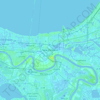
Navn: Topografisk kort New Orleans, højde, relief.
Gjennomsnittlig høyde: 1 m
Minste høyde: -5 m
Maksimal høyde: 32 m
Gi en donasjon
Andre topografiske kart
Klikk på et kart for å se dets topografi, dets høyde og dets relieff.
City Park
United States > Louisiana > Orleans Parish > New Orleans > Lakeview
Gjennomsnittlig høyde: 2 m