
Gi en donasjon
Topografisk kart Water Valley
Klikk på kartet for å vise høyde.
Gi en donasjon
Om dette kartet
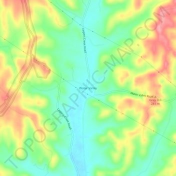
Navn: Topografisk kort Water Valley, højde, relief.
Gjennomsnittlig høyde: 214 m
Minste høyde: 168 m
Maksimal høyde: 275 m
Gi en donasjon
Andre topografiske kart
Klikk på et kart for å se dets topografi, dets høyde og dets relieff.
Columbia
United States > Tennessee > Maury County
According to the United States Census Bureau, the city has a total area of 29.6 square miles (77 km2), of which 29.6 square miles (77 km2) is land and 0.03% is water. Incorporated in 1817, the city is at an elevation of 637 feet (194 m).
Gjennomsnittlig høyde: 214 m
Gi en donasjon