
Gi en donasjon
Topografisk kart Kottayam
Klikk på kartet for å vise høyde.
Gi en donasjon
Kottayam
Kottayam has an average elevation of 3 metres (9.8 ft) above sea level. and is situated in the basin of the Meenachil River and in the basin of the Vembanad backwaters, which are formed from several streams in the Western Ghats in Idukki district. According to the division of places in Kerala based on altitudes, Kottayam is classified as being a midland area. The general soil type is alluvial soil. The vegetation is mainly tropical evergreen and moist deciduous type.
Gi en donasjon
Om dette kartet
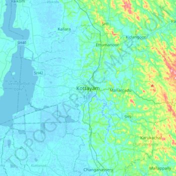
Navn: Topografisk kort Kottayam, højde, relief.
Sted: Kottayam, Kottayam District, Kerala, 686001, India (9.43156 76.36216 9.75156 76.68216)
Gjennomsnittlig høyde: 19 m
Minste høyde: -4 m
Maksimal høyde: 157 m
Gi en donasjon
Andre topografiske kart
Klikk på et kart for å se dets topografi, dets høyde og dets relieff.