
Gi en donasjon
Topografisk kart Lenore
Klikk på kartet for å vise høyde.
Gi en donasjon
Om dette kartet
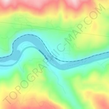
Navn: Topografisk kort Lenore, højde, relief.
Sted: Lenore, Nez Perce County, Idaho, United States (46.49851 -116.56098 46.51851 -116.54098)
Gjennomsnittlig høyde: 401 m
Minste høyde: 261 m
Maksimal høyde: 609 m
Gi en donasjon
Andre topografiske kart
Klikk på et kart for å se dets topografi, dets høyde og dets relieff.
Lewiston
United States > Idaho > Nez Perce County
According to the U.S. Census Bureau, the city has a total area of 18.04 square miles (46.72 km2), of which 17.23 square miles (44.63 km2) is land and 0.81 square miles (2.10 km2) is water. Downtown Lewiston, at elevations between 740 feet (230 m) and 780 feet (240 m), is only slightly higher in elevation than…
Gjennomsnittlig høyde: 334 m
Culdesac
United States > Idaho > Nez Perce County
Culdesac is located at 46°22′30″N 116°40′13″W / 46.37500°N 116.67028°W / 46.37500; -116.67028 (46.374883, -116.670333), at an elevation of 1,644 feet (501 m) above sea level.
Gjennomsnittlig høyde: 588 m