
Gi en donasjon
Topografisk kart Tekapo
Klikk på kartet for å vise høyde.
Gi en donasjon
Om dette kartet
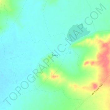
Navn: Topografisk kort Tekapo, højde, relief.
Sted: Tekapo, McKinley County, New Mexico, United States (35.00198 -108.96286 35.04198 -108.92286)
Gjennomsnittlig høyde: 1 900 m
Minste høyde: 1 881 m
Maksimal høyde: 1 950 m
Gi en donasjon
Andre topografiske kart
Klikk på et kart for å se dets topografi, dets høyde og dets relieff.
Gallup
United States > New Mexico > McKinley County
Gallup, like most of the interior Mountain West, has a cool semiarid climate (Köppen BSk). The summers are hot during the day, but the high altitude and low humidity mean that nights remain distinctly cool; as late as July 2, 1997, the temperature fell to 31 °F (−1 °C). Despite the large diurnal…
Gjennomsnittlig høyde: 2 067 m
Ramah
United States > New Mexico > McKinley County > Ramah
Lying at 6926 feet above sea level, Ramah is considered by some as a high desert, but at higher elevations in includes tall pines, sandstone cliffs, and timber covered mountains. Much of the lower landscape in the surrounding area is covered with lava flows from the chain of volcanos to the south. Intermixed…
Gjennomsnittlig høyde: 2 184 m
Gi en donasjon
Ramah
United States > New Mexico > McKinley County > Ramah
Lying at 6,926 feet (2,111 m) above sea level, Ramah is considered by some as a high desert, but at higher elevations it includes tall pines, sandstone cliffs, and timber-covered mountains. Much of the lower landscape in the surrounding area is covered with lava flows from the chain of volcanos to the south.
Gjennomsnittlig høyde: 2 184 m
Gi en donasjon
Gallup
United States > New Mexico > McKinley County
Gallup, like most of the interior Mountain West, has a cool semiarid climate (Köppen BSk). The summers are hot during the day, but the high altitude and low humidity mean that nights remain distinctly cool; as late as July 2, 1997, the temperature fell to 31 °F (−1 °C). Despite the large diurnal…
Gjennomsnittlig høyde: 2 067 m
Rock Springs
United States > New Mexico > McKinley County > Rock Springs
Gjennomsnittlig høyde: 2 022 m
Gi en donasjon
Crownpoint
United States > New Mexico > McKinley County
Crownpoint is in central McKinley County along New Mexico State Road 371, which leads south 23 miles (37 km) to Thoreau and Interstate 40, and north 83 miles (134 km) to Farmington. The community sits at an elevation of 6,851 feet (2,088 m) on land that drains toward the Chaco River 30 miles (48 km) to the…
Gjennomsnittlig høyde: 2 099 m