
Takk for at du støtter denne siden ❤️
Gi en donasjon
Gi en donasjon
Topografisk kart 太兴山
Klikk på kartet for å vise høyde.
Takk for at du støtter denne siden ❤️
Gi en donasjon
Gi en donasjon
Om dette kartet
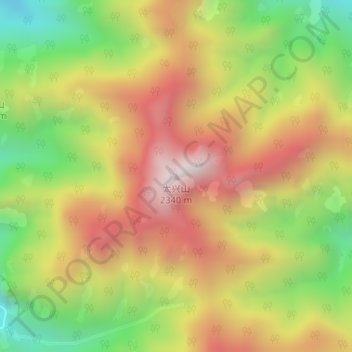
Navn: Topografisk kort 太兴山, højde, relief.
Sted: 太兴山, Xi'an, Shaanxi, China (33.94977 109.14333 33.94987 109.14343)
Gjennomsnittlig høyde: 1 801 m
Minste høyde: 1 299 m
Maksimal høyde: 2 281 m
Takk for at du støtter denne siden ❤️
Gi en donasjon
Gi en donasjon
Andre topografiske kart
Klikk på et kart for å se dets topografi, dets høyde og dets relieff.
Mount Taibai
The base of the mountain is composed of stone covered by yellow loess soil, while the middle elevations of the mountain are covered with hardy trees and spectacular rocky outcrops. The higher elevations of the mountain contain glacial remnants, cirque, peaks, aulacogen, and moraine, all of which have proven of…
Gjennomsnittlig høyde: 2 314 m