
Takk for at du støtter denne siden ❤️
Gi en donasjon
Gi en donasjon
Topografisk kart Keren
Klikk på kartet for å vise høyde.
Takk for at du støtter denne siden ❤️
Gi en donasjon
Gi en donasjon
Keren
Keren (Tigrinya and Tigre: ከረን, Arabic: كرن, Italian: Cheren), historically known as Sanhit, is the second-largest city in Eritrea. It is situated around 91 kilometres (57 mi) northwest of Asmara at an elevation of 1,590 metres (5,220 ft) above sea-level. The city sprawls on a wide basin surrounded by granitic mountains on all sides. It serves as the capital of the Anseba Region, and is home to a number of ethnic groups including the Bilen people and Tigre people.
Takk for at du støtter denne siden ❤️
Gi en donasjon
Gi en donasjon
Om dette kartet
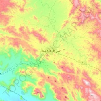
Navn: Topografisk kort Keren, højde, relief.
Sted: Keren, Anseba, Eritrea (15.62048 38.29361 15.94048 38.61361)
Gjennomsnittlig høyde: 1 456 m
Minste høyde: 811 m
Maksimal høyde: 2 359 m
Takk for at du støtter denne siden ❤️
Gi en donasjon
Gi en donasjon