
Gi en donasjon
Topografisk kart Harris Mountains
Klikk på kartet for å vise høyde.
Gi en donasjon
Om dette kartet
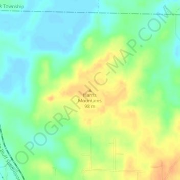
Navn: Topografisk kort Harris Mountains, højde, relief.
Gjennomsnittlig høyde: 82 m
Minste høyde: 67 m
Maksimal høyde: 100 m
Gi en donasjon
Andre topografiske kart
Klikk på et kart for å se dets topografi, dets høyde og dets relieff.
Pine Bluff
United States > Arkansas > Jefferson County
The city is situated in the Southeast section of the Arkansas Delta and straddles the Arkansas Timberlands region to its west. Its topography is flat with wide expanses of farmland, similar to other places in the Delta Lowlands. Pine Bluff has numerous creeks, streams, and bayous, including Bayou Bartholomew,…
Gjennomsnittlig høyde: 69 m
Gi en donasjon