
Gi en donasjon
Topografisk kart Aberlour
Klikk på kartet for å vise høyde.
Gi en donasjon
Aberlour
According to the 1846 A Topographical Dictionary of Scotland, "This parish, formerly called Skirdustan, signifying, in the Gaelic tongue, 'the division of Dustan', its tutelary saint, derived its present name from its situation at the mouth of a noisy burn, which discharges itself into the river Spey."
Gi en donasjon
Om dette kartet
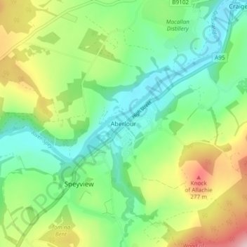
Navn: Topografisk kort Aberlour, højde, relief.
Sted: Aberlour, Moray, Scotland, AB38 9PX, United Kingdom (57.45079 -3.24554 57.49079 -3.20554)
Gjennomsnittlig høyde: 160 m
Minste høyde: 75 m
Maksimal høyde: 326 m
Gi en donasjon
Andre topografiske kart
Klikk på et kart for å se dets topografi, dets høyde og dets relieff.
Fochabers
United Kingdom > Scotland > Moray
The present village owes its existence to Alexander Gordon, 4th Duke of Gordon (1743–1827). During the late eighteenth century, during the Scottish Enlightenment, it was fashionable for landowners to found new towns and villages; these can be recognised all over Scotland, because unlike their predecessors…
Gjennomsnittlig høyde: 59 m
Gi en donasjon