
Gi en donasjon
Topografisk kart Box Canyon
Klikk på kartet for å vise høyde.
Gi en donasjon
Om dette kartet
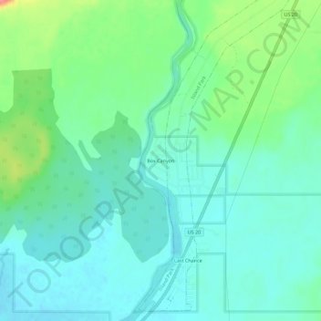
Navn: Topografisk kort Box Canyon, højde, relief.
Sted: Box Canyon, Fremont County, Idaho, United States (44.35721 -111.42534 44.39721 -111.38534)
Gjennomsnittlig høyde: 1 891 m
Minste høyde: 1 871 m
Maksimal høyde: 1 948 m
Gi en donasjon
Andre topografiske kart
Klikk på et kart for å se dets topografi, dets høyde og dets relieff.
Island Park
United States > Idaho > Fremont County
Island Park is located at 44°29′59″N 111°20′19″W / 44.49972°N 111.33861°W / 44.49972; -111.33861 (44.4996, −111.3387), at an elevation of 6,293 feet (1,918 m) above sea level, making it the highest city in Idaho.
Gjennomsnittlig høyde: 2 113 m
Newdale
United States > Idaho > Fremont County
Newdale is the nearest city to the Teton Dam, which failed on June 5, 1976. Newdale did not receive any flooding or damage, due to its elevation and position relative to the dam.
Gjennomsnittlig høyde: 1 550 m
Sand Mountain Wilderness Study Area
United States > Idaho > Fremont County
Gjennomsnittlig høyde: 1 566 m
Newdale
United States > Idaho > Fremont County
Newdale is the nearest city to the Teton Dam, which failed on June 5, 1976. Newdale did not receive any flooding or damage, due to its elevation and position relative to the dam.
Gjennomsnittlig høyde: 1 550 m
Gi en donasjon
Island Park
United States > Idaho > Fremont County
Island Park is located at 44°29′59″N 111°20′19″W / 44.49972°N 111.33861°W / 44.49972; -111.33861 (44.4996, −111.3387), at an elevation of 6,293 feet (1,918 m) above sea level, making it the highest city in Idaho.
Gjennomsnittlig høyde: 2 113 m