
Gi en donasjon
Topografisk kart Qingcheng Mountain
Klikk på kartet for å vise høyde.
Gi en donasjon
Qingcheng Mountain
"Located at the peak of Mount Qingcheng with an altitude over 1,500 m, Shangqing Palace marks the end of the touring route of Mount Qingcheng. Buildings such as Laojun Hall, Sanqing Hall, Wenwu Hall, and Tao Te Ching Preaching Hall in the Taoist temple of Shangqing Palace with several cultural relics, were originally built in the Jin Dynasty."
Gi en donasjon
Om dette kartet
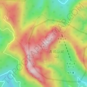
Navn: Topografisk kort Qingcheng Mountain, højde, relief.
Sted: Qingcheng Mountain, Chengdu, Sichuan, 611844, China (30.91045 103.55773 30.91055 103.55783)
Gjennomsnittlig høyde: 972 m
Minste høyde: 718 m
Maksimal høyde: 1 222 m
Gi en donasjon
Andre topografiske kart
Klikk på et kart for å se dets topografi, dets høyde og dets relieff.
Wuhou District
The terrain of Wuhou District is flat, sloping from northwest to southeast, with an average altitude of 502.5 meters. The plains within the territory are composed of flood plains, alluvial fans, fan plains and other plains. The geological structure of the entire region is mainly Quaternary loose accumulations.
Gjennomsnittlig høyde: 492 m
Gi en donasjon