
Gi en donasjon
Topografisk kart Barren Springs
Klikk på kartet for å vise høyde.
Gi en donasjon
Om dette kartet
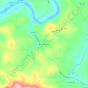
Navn: Topografisk kort Barren Springs, højde, relief.
Sted: Barren Springs, Wythe County, Virginia, 24313, United States (36.88818 -80.82063 36.92818 -80.78063)
Gjennomsnittlig høyde: 642 m
Minste høyde: 564 m
Maksimal høyde: 784 m
Gi en donasjon
Andre topografiske kart
Klikk på et kart for å se dets topografi, dets høyde og dets relieff.
Wytheville
United States > Virginia > Wythe County
Wytheville is nestled within the scenic Appalachian Mountains, characterized by a varied topography that features rolling hills, gentle valleys, and steep ridges. The town sits at an elevation of approximately 2,300 feet, which contributes to its cooler climate and offers picturesque views of the surrounding…
Gjennomsnittlig høyde: 720 m
Gi en donasjon
Wytheville
United States > Virginia > Wythe County
Due to its elevation, the climate of Wytheville is either classified as mountain temperate or humid subtropical (Köppen Cfb or Cfa, respectively), and the town straddles the border between USDA Plant Hardiness Zones 6B and 7A. Summers are warm and humid, although significantly cooler than low-elevation places…
Gjennomsnittlig høyde: 720 m