
Gi en donasjon
Topografisk kart Mount Bangs
Klikk på kartet for å vise høyde.
Gi en donasjon
Om dette kartet
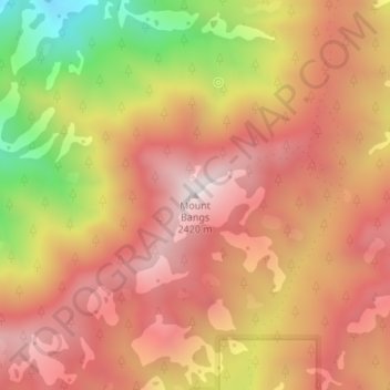
Navn: Topografisk kort Mount Bangs, højde, relief.
Sted: Mount Bangs, Mohave County, Arizona, United States (36.79243 -113.85501 36.79253 -113.85491)
Gjennomsnittlig høyde: 2 049 m
Minste høyde: 1 442 m
Maksimal høyde: 2 414 m
Gi en donasjon
Andre topografiske kart
Klikk på et kart for å se dets topografi, dets høyde og dets relieff.
Kingman
United States > Arizona > Mohave County > Kingman
Lt. Edward Fitzgerald Beale, a U.S. Navy officer in the service of the U.S. Army Corps of Topographical Engineers, was ordered by the U.S. War Department to build a federal wagon road across the 35th Parallel. His secondary orders were to test the feasibility of the use of camels as pack animals in the…
Gjennomsnittlig høyde: 1 131 m
Gi en donasjon
Kingman
United States > Arizona > Mohave County
Lt. Edward Fitzgerald Beale, a U.S. Navy officer in the service of the Army Corps of Topographical Engineers, was ordered by the U.S. War Department to build a federal wagon road across the 35th parallel. His secondary orders were to test the feasibility of the use of camels as pack animals in the Southwestern…
Gjennomsnittlig høyde: 1 131 m
Gi en donasjon
Fort Mojave Indian Tribe
United States > Arizona > Mohave County > Mohave Valley
Gjennomsnittlig høyde: 362 m
Gi en donasjon