
Gi en donasjon
Topografisk kart Cocolalla
Klikk på kartet for å vise høyde.
Gi en donasjon
Om dette kartet
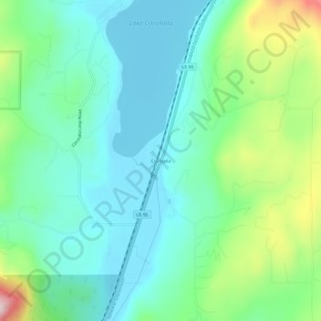
Navn: Topografisk kort Cocolalla, højde, relief.
Sted: Cocolalla, Bonner County, Idaho, 83813, United States (48.08797 -116.63742 48.12797 -116.59742)
Gjennomsnittlig høyde: 754 m
Minste høyde: 670 m
Maksimal høyde: 998 m
Gi en donasjon
Andre topografiske kart
Klikk på et kart for å se dets topografi, dets høyde og dets relieff.
Hope
United States > Idaho > Bonner County
Hope is located at 48°14′55″N 116°18′33″W / 48.24861°N 116.30917°W / 48.24861; -116.30917 (48.248728, -116.309214), at an elevation of 2,192 feet (668 m) above sea level. The city sits on the northeast shore of Lake Pend Oreille.
Gjennomsnittlig høyde: 763 m
Ponderay
United States > Idaho > Bonner County
Ponderay is located at 48°18′11″N 116°32′18″W / 48.30306°N 116.53833°W / 48.30306; -116.53833 (48.303080, -116.538292), at an elevation of 2,126 feet (648 m) above sea level. According to the United States Census Bureau, the city has a total area of 3.02 square miles (7.82 km2), of which,…
Gjennomsnittlig høyde: 652 m
Gi en donasjon
Priest River
United States > Idaho > Bonner County
Priest River is located at 48°11′0″N 116°54′34″W / 48.18333°N 116.90944°W / 48.18333; -116.90944 (48.183388, -116.909555), at an elevation of 2,139 feet (652 m) above sea level.
Gjennomsnittlig høyde: 742 m
Priest River
United States > Idaho > Bonner County
Priest River is located at 48°11′0″N 116°54′34″W / 48.18333°N 116.90944°W / 48.18333; -116.90944 (48.183388, -116.909555), at an elevation of 2,139 feet (652 m) above sea level.
Gjennomsnittlig høyde: 742 m
Oldtown
United States > Idaho > Bonner County
Oldtown is located at 48°11′8″N 117°1′49″W / 48.18556°N 117.03028°W / 48.18556; -117.03028 (48.185623, -117.030158), at an elevation of 2,134 feet (650 meters).
Gjennomsnittlig høyde: 682 m
Gi en donasjon
Clark Fork
United States > Idaho > Bonner County
Clark Fork is located at 48°8′50″N 116°10′42″W / 48.14722°N 116.17833°W / 48.14722; -116.17833 (48.147180, -116.178270), at an elevation of 2,090 feet (637 m) above sea level. The town is situated on the Clark Fork River, on the eastern shores of Lake Pend Oreille. in the northern…
Gjennomsnittlig høyde: 681 m