
Gi en donasjon
Topografisk kart Kings Peak
Klikk på kartet for å vise høyde.
Gi en donasjon
Kings Peak
Kings Peak is the highest peak in the U.S. state of Utah, with an elevation of 13,528 feet (4,123 m) NAVD 88.
Gi en donasjon
Om dette kartet
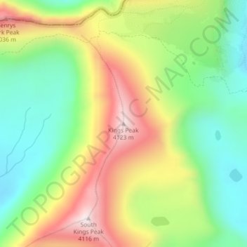
Navn: Topografisk kort Kings Peak, højde, relief.
Sted: Kings Peak, Duchesne County, Utah, United States (40.77619 -110.37285 40.77629 -110.37275)
Gjennomsnittlig høyde: 3 743 m
Minste høyde: 3 469 m
Maksimal høyde: 4 118 m
Gi en donasjon
Andre topografiske kart
Klikk på et kart for å se dets topografi, dets høyde og dets relieff.
Roosevelt
United States > Utah > Duchesne County
Roosevelt is situated on U.S. Route 40 in the northeast corner of the state, south of the Uinta Mountains, at an elevation of 5,250 feet (1,600 m). The town was incorporated at a mass meeting of 44 citizens on 21 February 1913. From 1906 to 1914 Roosevelt was in Wasatch County, but in 1914 Duchesne County was…
Gjennomsnittlig høyde: 1 553 m
Gi en donasjon