
Gi en donasjon
Topografisk kart Alpine
Klikk på kartet for å vise høyde.
Gi en donasjon
Om dette kartet
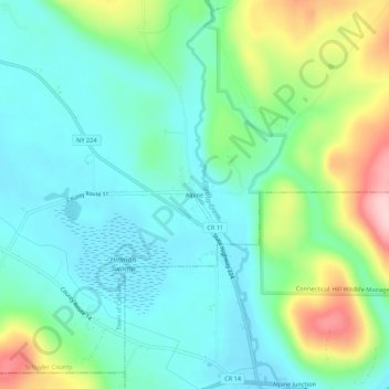
Navn: Topografisk kort Alpine, højde, relief.
Gjennomsnittlig høyde: 398 m
Minste høyde: 338 m
Maksimal høyde: 555 m
Gi en donasjon
Andre topografiske kart
Klikk på et kart for å se dets topografi, dets høyde og dets relieff.
Finger Lakes National Forest
United States > New York > Schuyler County > Town of Hector
Gjennomsnittlig høyde: 356 m
Cinnamon Lake
United States > New York > Schuyler County > Town of Orange
Gjennomsnittlig høyde: 568 m
Gi en donasjon
Watkins Glen State Park
United States > New York > Schuyler County > Watkins Glen
During the Pleistocene era, a vast area was covered by ice during the maximum extent of glacial ice in the north polar area. The movement of glaciers from the Laurentide and Wisconsin ice sheets shaped the Finger Lakes region. The lakes originated as a series of northward-flowing streams. Around two million…
Gjennomsnittlig høyde: 392 m
Lamoka Lake
United States > New York > Schuyler County > Town of Tyrone > Weston
Gjennomsnittlig høyde: 351 m
Gi en donasjon
Finger Lakes National Forest
United States > New York > Schuyler County > Town of Hector
Gjennomsnittlig høyde: 356 m
Gi en donasjon