
Gi en donasjon
Topografisk kart Walnut Hill
Klikk på kartet for å vise høyde.
Gi en donasjon
Om dette kartet
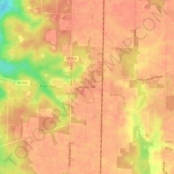
Navn: Topografisk kort Walnut Hill, højde, relief.
Sted: Walnut Hill, Escambia County, Florida, United States (30.86546 -87.52998 30.90546 -87.48998)
Gjennomsnittlig høyde: 74 m
Minste høyde: 37 m
Maksimal høyde: 83 m
Gi en donasjon
Andre topografiske kart
Klikk på et kart for å se dets topografi, dets høyde og dets relieff.
Pensacola
United States > Florida > Escambia County
Pensacola features a diverse topography characterized primarily by its proximity to the Gulf of Mexico and the sheltered Pensacola Bay. The terrain gently slopes upward from the waterfront, resulting in a gradual elevation that provides natural protection against storm surges, making it somewhat less…
Gjennomsnittlig høyde: 21 m
Pensacola
United States > Florida > Escambia County
The land is sloped up northward from Pensacola Bay, with most of the city at an elevation above that which a potential hurricane storm surge could affect.
Gjennomsnittlig høyde: 21 m
Pensacola
United States > Florida > Escambia County
The land is sloped up northward from Pensacola Bay, with most of the city at an elevation above that which a potential hurricane storm surge could affect.
Gjennomsnittlig høyde: 21 m
Gi en donasjon
Pensacola
United States > Florida > Escambia County
The land is sloped up northward from Pensacola Bay, with most of the city at an elevation above that at which a potential hurricane storm surge could affect.
Gjennomsnittlig høyde: 21 m
Pensacola
United States > Florida > Escambia County
The land is sloped up northward from Pensacola Bay, with most of the city at an elevation above that at which a potential hurricane storm surge could affect.
Gjennomsnittlig høyde: 21 m
Gi en donasjon