
Gi en donasjon
Topografisk kart Mount Washburn
Klikk på kartet for å vise høyde.
Gi en donasjon
Mount Washburn
Mount Washburn, elevation 10,219 feet (3,115 m), is a prominent mountain peak in the Washburn Range in Yellowstone National Park, Wyoming. The peak was named in 1870 to honor Henry D. Washburn, leader of the Washburn–Langford–Doane Expedition. The Washburn Range is one of two mountains ranges completely within the boundaries of Yellowstone.
Gi en donasjon
Om dette kartet
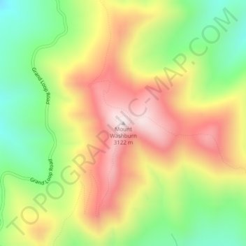
Navn: Topografisk kort Mount Washburn, højde, relief.
Sted: Mount Washburn, Park County, Wyoming, United States (44.79751 -110.43384 44.79761 -110.43374)
Gjennomsnittlig høyde: 2 798 m
Minste høyde: 2 503 m
Maksimal høyde: 3 109 m
Gi en donasjon
Andre topografiske kart
Klikk på et kart for å se dets topografi, dets høyde og dets relieff.
Cody
United States > Wyoming > Park County
Cody's elevation is approximately 5016 ft (1,500 m) above sea level. The main part of the city is split across three levels, separated by about 60 feet (18 m).
Gjennomsnittlig høyde: 1 557 m
Cody
United States > Wyoming > Park County
Cody's elevation is approximately 5016 ft (1,500 m) above sea level. The main part of the city is split across three levels, separated by about 60 feet (18 m).
Gjennomsnittlig høyde: 1 557 m
Gi en donasjon
Cody
United States > Wyoming > Park County
Cody's elevation is approximately 4,997 feet (1,523 m) above sea level. The main part of the city is split across three levels, separated by about 60 feet (18 m).
Gjennomsnittlig høyde: 1 557 m