
Gi en donasjon
Topografisk kart Cape Hatteras
Klikk på kartet for å vise høyde.
Gi en donasjon
Cape Hatteras
Long stretches of beach, sand dunes, marshes, and maritime forests create a unique environment where wind and waves shape the topography. A large area of the Outer Banks is part of a National Park, called the Cape Hatteras National Seashore. It is also the nearest landmass on the North American mainland to Bermuda, which is about 563 nautical miles (648 mi; 1,043 km) to the east-southeast.
Gi en donasjon
Om dette kartet
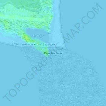
Navn: Topografisk kort Cape Hatteras, højde, relief.
Gjennomsnittlig høyde: 1 m
Minste høyde: -2 m
Maksimal høyde: 9 m
Gi en donasjon
Andre topografiske kart
Klikk på et kart for å se dets topografi, dets høyde og dets relieff.
Kill Devil Hills
United States > North Carolina > Dare County
First Flight Airport covers an area of 40 acres at an elevation of 13 feet (4 metres) above mean sea level. It has one runway; designated 2/20, with an asphalt surface measuring 3,000 by 60 feet (914 by 18 metres). For the 12-month period ending August 19, 2009, the airport had 38,120 aircraft operations, an…
Gjennomsnittlig høyde: 2 m
Gi en donasjon
Gi en donasjon
Kill Devil Hills
United States > North Carolina > Dare County
First Flight Airport covers an area of 40 acres at an elevation of 13 feet (4 metres) above mean sea level. It has one runway; designated 3/21, with an asphalt surface measuring 3,000 by 60 feet (914 by 18 metres). For the 12-month period ending August 19, 2009, the airport had 38,120 aircraft operations, an…
Gjennomsnittlig høyde: 2 m
Cape Hatteras National Seashore
United States > North Carolina > Dare County > Nags Head
Gjennomsnittlig høyde: 0 m
Gi en donasjon
Kitty Hawk
United States > North Carolina > Dare County
Kitty Hawk is located at 36°06′N 75°42′W / 36.1°N 75.7°W / 36.1; -75.7 at an elevation of 7 feet (2 m) above sea level.
Gjennomsnittlig høyde: 2 m
Gi en donasjon
Kill Devil Hills
United States > North Carolina > Dare County
First Flight Airport covers an area of 40 acres at an elevation of 13 feet (4 metres) above mean sea level. It has one runway; designated 2/20, with an asphalt surface measuring 3,000 by 60 feet (914 by 18 metres). For the 12-month period ending August 19, 2009, the airport had 38,120 aircraft operations, an…
Gjennomsnittlig høyde: 2 m
Cape Hatteras National Seashore
United States > North Carolina > Dare County > Nags Head
Gjennomsnittlig høyde: 0 m