
Gi en donasjon
Topografisk kart Kanhangad
Klikk på kartet for å vise høyde.
Gi en donasjon
Kanhangad
Kanhangad lies at 12°18′0″N 75°5.4′0″E in the geographic map of Kasaragod. It is a coastal town which has a varied topography with plain areas in the centre of the city. The landscape is dominated by the characteristic coconut palms accompanying rolling hills and streams flowing into the sea. In the East, there are hilly areas of Madikai . The western region has powdered sand and a mix of laterite and alluvial soil in the areas between. The hilly areas typically consists of red sand.
Gi en donasjon
Om dette kartet
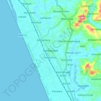
Navn: Topografisk kort Kanhangad, højde, relief.
Sted: Kanhangad, Hosdurg, Kasaragod District, Kerala, 671315, India (12.27356 75.05246 12.35356 75.13246)
Gjennomsnittlig høyde: 18 m
Minste høyde: -6 m
Maksimal høyde: 169 m
Gi en donasjon
Andre topografiske kart
Klikk på et kart for å se dets topografi, dets høyde og dets relieff.