
Gi en donasjon
Topografisk kart St. Simons
Klikk på kartet for å vise høyde.
Gi en donasjon
Om dette kartet
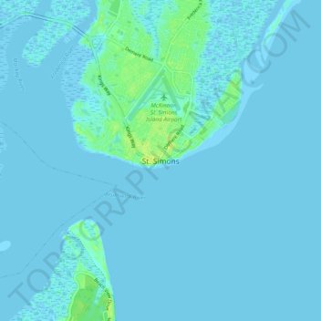
Navn: Topografisk kort St. Simons, højde, relief.
Sted: St. Simons, Glynn County, Georgia, 31522, United States (31.09538 -81.42952 31.17538 -81.34952)
Gjennomsnittlig høyde: 2 m
Minste høyde: -3 m
Maksimal høyde: 14 m
Gi en donasjon
Andre topografiske kart
Klikk på et kart for å se dets topografi, dets høyde og dets relieff.
Brunswick
United States > Georgia > Glynn County
The city is the lowest in the U.S. state of Georgia, with an elevation of only 10 to 14 feet (3.0 to 4.3 m) above sea level. According to the U.S. Census Bureau, Brunswick's land area is 32.4 square miles (83.8 km2). Its total area is 42.4 square miles (109.8 km2); 10.0 square miles (26.0 km2) of this is water.
Gjennomsnittlig høyde: 2 m
Gi en donasjon