
Gi en donasjon
Topografisk kart Yonkers
Klikk på kartet for å vise høyde.
Gi en donasjon
Om dette kartet
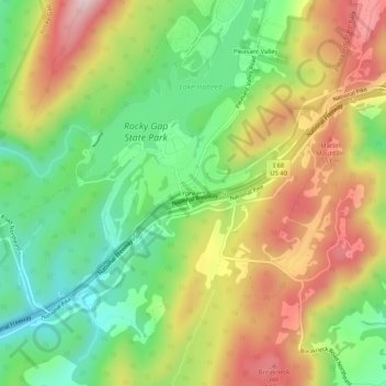
Navn: Topografisk kort Yonkers, højde, relief.
Sted: Yonkers, Allegany County, Maryland, United States (39.67509 -78.66891 39.71509 -78.62891)
Gjennomsnittlig høyde: 426 m
Minste høyde: 263 m
Maksimal høyde: 628 m
Gi en donasjon
Andre topografiske kart
Klikk på et kart for å se dets topografi, dets høyde og dets relieff.
Frostburg
United States > Maryland > Allegany County
Due to its average elevation of 2,000 feet (610 m) above sea level and location near the Allegheny Front, Frostburg has a colder, wetter climate than much of the rest of the state, and falls in USDA hardiness zone 6b. Under the Köppen climate classification, it has a humid continental climate (Dfb), with…
Gjennomsnittlig høyde: 620 m
Little Orleans
United States > Maryland > Allegany County > Little Orleans
Gjennomsnittlig høyde: 182 m
Rocky Gap State Park
United States > Maryland > Allegany County > Pleasant Grove
Gjennomsnittlig høyde: 412 m
Gi en donasjon
Frostburg
United States > Maryland > Allegany County
Due to its average elevation of 2,000 feet (610 m) above sea level and location near the Allegheny Front, Frostburg has a colder, wetter climate than much of the rest of the state, and falls in USDA hardiness zone 6b. Under the Köppen climate classification, it has a humid continental climate (Dfb), with…
Gjennomsnittlig høyde: 620 m