
Takk for at du støtter denne siden ❤️
Gi en donasjon
Gi en donasjon
Topografisk kart Laguna Vista
Klikk på kartet for å vise høyde.
Takk for at du støtter denne siden ❤️
Gi en donasjon
Gi en donasjon
Om dette kartet
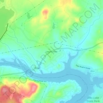
Navn: Topografisk kort Laguna Vista, højde, relief.
Sted: Laguna Vista, Burnet County, Texas, United States (30.73625 -98.40766 30.77625 -98.36766)
Gjennomsnittlig høyde: 297 m
Minste høyde: 270 m
Maksimal høyde: 363 m
Takk for at du støtter denne siden ❤️
Gi en donasjon
Gi en donasjon
Andre topografiske kart
Klikk på et kart for å se dets topografi, dets høyde og dets relieff.
Inks Lake State Park
United States > Texas > Burnet County > Burnet
Conservation Pool Elevation usually stays around 888.22 ft. msl; however, this lake does fluctuate about 1 foot annually. Inks lake water clarity can be seen as clear to slightly stained mostly throughout the year. It tends to have higher turbidity during the rainy season due to excessive amounts of runoff.
Gjennomsnittlig høyde: 294 m
Takk for at du støtter denne siden ❤️
Gi en donasjon
Gi en donasjon
Takk for at du støtter denne siden ❤️
Gi en donasjon
Gi en donasjon