
Gi en donasjon
Topografisk kart Ambasamudram
Klikk på kartet for å vise høyde.
Gi en donasjon
Ambasamudram
Maancholai Hills is located between elevations ranging from 1,000 to 1,500 metres. The Maancholai area is deep within the Western Ghats, within the Kalakad Mundanthurai Tiger Reserve in the Tirunelveli District. Located on top of the Manimuthar Dam and the Manimuthar Water Falls, the Maancholai area comprises tea plantations, small settlements around the plantations; Upper Kodaiyar Dam and a windy view point called Kuthiravetti. Manimuttar Dam, Gadananathi River Dam, Rice Research Station of TNAU, Papanasam Dam, Karaiyar Dam, Singampatti Zamin palace, Servalar Dam, Kalakkad Mundanthurai Tiger Reserve, Agasthiyar Falls fed by lower dam., Baana Theertham Falls, Tamirabarani river, Sri Vedhanarayanar Rajagopalaswami Kulasekhara Azhwar Temple, Papanasaswamy Temple, Agashtiyar Temple, Krishnaswamy temple, kasi viswanathar temple and Durgai Amman Temple are the popular visitor attractions around the town.Also Papanasm , Agasthiyar falls which is around 5 Km from Ambasamudram.
Gi en donasjon
Om dette kartet
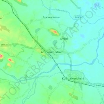
Navn: Topografisk kort Ambasamudram, højde, relief.
Sted: Ambasamudram, Tirunelveli District, Tamil Nadu, 627400, India (8.66389 77.40755 8.74389 77.48755)
Gjennomsnittlig høyde: 71 m
Minste høyde: 51 m
Maksimal høyde: 147 m
Gi en donasjon
Andre topografiske kart
Klikk på et kart for å se dets topografi, dets høyde og dets relieff.
Kalakkad Mundanthurai Tiger Reserve
India > Tamil Nadu > Ambasamudram
The reserve spans a range of 40 to 1,800 m in elevation. Agasthiyamalai (1681 m.) is in the core zone of the reserve.
Gjennomsnittlig høyde: 395 m