
Gi en donasjon
Topografisk kart Goats Bluff
Klikk på kartet for å vise høyde.
Gi en donasjon
Om dette kartet
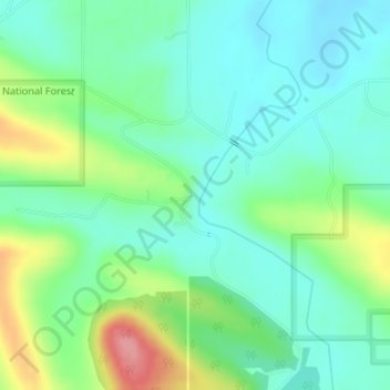
Navn: Topografisk kort Goats Bluff, højde, relief.
Sted: Goats Bluff, LeFlore County, Oklahoma, United States (34.87588 -94.85667 34.87598 -94.85657)
Gjennomsnittlig høyde: 179 m
Minste høyde: 149 m
Maksimal høyde: 252 m
Gi en donasjon
Andre topografiske kart
Klikk på et kart for å se dets topografi, dets høyde og dets relieff.
Poteau
United States > Oklahoma > LeFlore County
The city is located in the valley below Cavanal Hill, dubbed the "World's Highest Hill" with a signed elevation of 1,999 feet (609 m). The location was a subject of extensive coal mining in the first half of the 20th Century, and a railway, eventually called the Poteau and Cavanal Mountain Railroad, served the…
Gjennomsnittlig høyde: 189 m
Gi en donasjon
Poteau
United States > Oklahoma > LeFlore County
The city is located in the valley below Cavanal Hill, dubbed the "World's Highest Hill" with a signed elevation of 1,999 feet (609 m). The location was a subject of extensive coal mining in the first half of the 20th century, and a railway, eventually called the Poteau and Cavanal Mountain Railroad, served the…
Gjennomsnittlig høyde: 189 m
Gi en donasjon
Poteau
United States > Oklahoma > LeFlore County
The city is located in the valley below Cavanal Hill, dubbed the "World's Highest Hill" with a signed elevation of 1,999 feet (609 m). The location was a subject of extensive coal mining in the first half of the 20th Century, and a railway, eventually called the Poteau and Cavanal Mountain Railroad, served the…
Gjennomsnittlig høyde: 189 m