
Gi en donasjon
Topografisk kart Salem
Klikk på kartet for å vise høyde.
Gi en donasjon
Om dette kartet
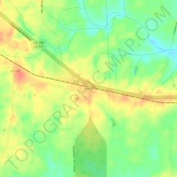
Navn: Topografisk kort Salem, højde, relief.
Sted: Salem, Lee County, Alabama, United States (32.57680 -85.25855 32.61680 -85.21855)
Gjennomsnittlig høyde: 198 m
Minste høyde: 171 m
Maksimal høyde: 224 m
Gi en donasjon
Andre topografiske kart
Klikk på et kart for å se dets topografi, dets høyde og dets relieff.
Auburn
United States > Alabama > Lee County
The southwest and west regions of the city on the plateau are marked by rolling plains and savannahs, with the undeveloped portion primarily being used for cattle grazing and ranching. South of this region sits the coastal plain, with sandy soil and pine forest. Parts of north Auburn have much more rugged…
Gjennomsnittlig høyde: 200 m
Gi en donasjon
Auburn
United States > Alabama > Lee County
The southwest and west regions of the city on the plateau are marked by rolling plains and savannahs, with the undeveloped portion primarily being used for cattle grazing and ranching. South of this region sits the coastal plain, with sandy soil and pine forest. Parts of north Auburn have much more rugged…
Gjennomsnittlig høyde: 200 m
Gi en donasjon
Auburn
United States > Alabama > Lee County
The southwest and west regions of the city on the plateau are marked by rolling plains and savannahs, with the undeveloped portion primarily being used for cattle grazing and ranching. South of this region sits the coastal plain, with sandy soil and pine forest. Parts of north Auburn have much more rugged…
Gjennomsnittlig høyde: 208 m
Auburn
United States > Alabama > Lee County
The southwest and west regions of the city on the plateau are marked by rolling plains and savannahs, with the undeveloped portion primarily being used for cattle grazing and ranching. South of this region sits the coastal plain, with sandy soil and pine forest. Parts of north Auburn have much more rugged…
Gjennomsnittlig høyde: 200 m