
Takk for at du støtter denne siden ❤️
Gi en donasjon
Gi en donasjon
Topografisk kart South Marsh Island
Klikk på kartet for å vise høyde.
Takk for at du støtter denne siden ❤️
Gi en donasjon
Gi en donasjon
Om dette kartet
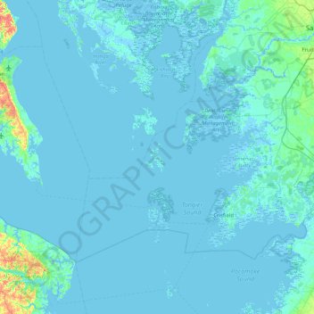
Navn: Topografisk kort South Marsh Island, højde, relief.
Sted: South Marsh Island, Somerset County, Maryland, United States (37.78154 -76.34505 38.42154 -75.70505)
Gjennomsnittlig høyde: 2 m
Minste høyde: -4 m
Maksimal høyde: 41 m
Takk for at du støtter denne siden ❤️
Gi en donasjon
Gi en donasjon
Andre topografiske kart
Klikk på et kart for å se dets topografi, dets høyde og dets relieff.
Takk for at du støtter denne siden ❤️
Gi en donasjon
Gi en donasjon
Crisfield
United States > Maryland > Somerset County
Crisfield is a very compact city, with little vacant land. According to the United States Census Bureau, the city has a total area of 3.06 square miles (7.93 km2), of which 1.62 square miles (4.20 km2) (53.0%) is land and 1.44 square miles (3.73 km2) (47.0%) is water. As one of the southern points on the…
Gjennomsnittlig høyde: 1 m