
Gi en donasjon
Topografisk kart Cerro de la Cruz
Klikk på kartet for å vise høyde.
Gi en donasjon
Om dette kartet
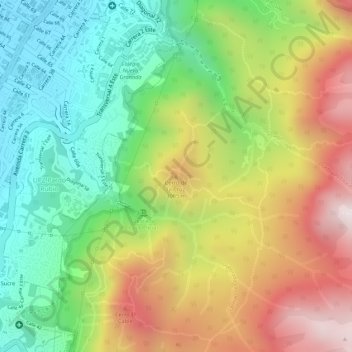
Navn: Topografisk kort Cerro de la Cruz, højde, relief.
Gjennomsnittlig høyde: 2 902 m
Minste høyde: 2 574 m
Maksimal høyde: 3 302 m
Gi en donasjon
Andre topografiske kart
Klikk på et kart for å se dets topografi, dets høyde og dets relieff.
Bogota
Colombia > Bogota, Capital District
Bogotá is located in the southeastern part of the Bogotá savanna (Sabana de Bogotá) at an average altitude of 2,640 meters (8,660 ft) above sea level. The Bogotá savanna is popularly called "savannah" (sabana), but constitutes actually a high plateau in the Andes mountains, part of an extended region known…
Gjennomsnittlig høyde: 2 711 m
Bogota
Colombia > Bogota, Capital District
The city is located in the center of Colombia, on a high plateau known as the Bogotá savanna, part of the Altiplano Cundiboyacense located in the Eastern Cordillera of the Andes. Its altitude averages 2,640 meters (8,660 ft) above sea level. Subdivided into 20 localities, Bogotá covers an area of 1,587…
Gjennomsnittlig høyde: 2 711 m
Bogota
Colombia > Bogota, Capital District
The city is located in the center of Colombia, on a high plateau known as the Bogotá savanna, part of the Altiplano Cundiboyacense located in the Eastern Cordillera of the Andes. Its altitude averages 2,640 meters (8,660 ft) above sea level, making it the third highest capital city in the world. Subdivided…
Gjennomsnittlig høyde: 2 711 m
Gi en donasjon
Bogota Capital District - Municipality
Colombia > Bogota, Capital District
The city is located in the center of Colombia, on a high plateau known as the Bogotá savanna, part of the Altiplano Cundiboyacense located in the Eastern Cordillera of the Andes. Its altitude averages 2,640 meters (8,660 ft) above sea level. Subdivided into 20 localities, Bogotá has an area of 1,587 square…
Gjennomsnittlig høyde: 2 135 m
Bogota
Colombia > Bogota, Capital District
The city is located in the center of Colombia, on a high plateau known as the Bogotá savanna, part of the Altiplano Cundiboyacense located in the Eastern Cordillera of the Andes. Its altitude averages 2,640 meters (8,660 ft) above sea level, making it the third highest capital city in the world. Subdivided…
Gjennomsnittlig høyde: 2 712 m
Bogota
Colombia > Bogota, Capital District
The city is located in the center of Colombia, on a high plateau known as the Bogotá savanna, part of the Altiplano Cundiboyacense located in the Eastern Cordillera of the Andes. Its altitude averages 2,640 meters (8,660 ft) above sea level. Subdivided into 20 localities, Bogotá has an area of 1,587 square…
Gjennomsnittlig høyde: 2 711 m
Gi en donasjon
Bogota
Colombia > Bogota, Capital District
The city is located in the center of Colombia, on a high plateau known as the Bogotá savanna, part of the Altiplano Cundiboyacense located in the Eastern Cordillera of the Andes. Its altitude averages 2,640 meters (8,660 ft) above sea level. Subdivided into 20 localities, Bogotá covers an area of 1,587…
Gjennomsnittlig høyde: 2 712 m
Bogota
Colombia > Bogota, Capital District
The city is located in the center of Colombia, on a high plateau known as the Bogotá savanna, part of the Altiplano Cundiboyacense located in the Eastern Cordillera of the Andes. Its altitude averages 2,640 meters (8,660 ft) above sea level. Subdivided into 20 localities, Bogotá covers an area of 1,587…
Gjennomsnittlig høyde: 2 711 m
Bogota Capital District - Municipality
Colombia > Bogota, Capital District
Bogotá is located in the southeastern part of the Bogotá savanna (Sabana de Bogotá) at an average altitude of 2,640 meters (8,660 ft) above sea level. The Bogotá savanna is popularly called "savannah" (sabana), but constitutes actually a high plateau in the Andes mountains, part of an extended region known…
Gjennomsnittlig høyde: 2 135 m