
Takk for at du støtter denne siden ❤️
Gi en donasjon
Gi en donasjon
Topografisk kart Lower Ninth Ward
Klikk på kartet for å vise høyde.
Takk for at du støtter denne siden ❤️
Gi en donasjon
Gi en donasjon
Lower Ninth Ward
The most severely damaged section of the Ward was the lower elevation section, north of Claiborne Avenue. A Bring Back New Orleans Commission preliminary report suggested making this area in whole or part into park space because of the high risk of future flooding. Most Lower 9th Ward residents have strongly objected to this proposal, but outsiders worry about the high risk of future flooding in the area.
Takk for at du støtter denne siden ❤️
Gi en donasjon
Gi en donasjon
Om dette kartet
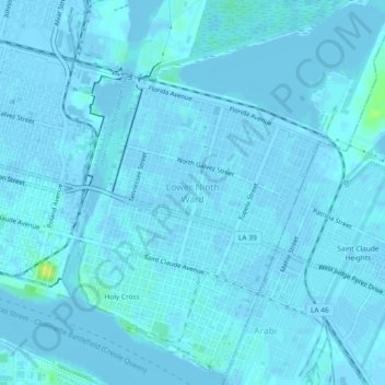
Navn: Topografisk kort Lower Ninth Ward, højde, relief.
Gjennomsnittlig høyde: 1 m
Minste høyde: -4 m
Maksimal høyde: 16 m
Takk for at du støtter denne siden ❤️
Gi en donasjon
Gi en donasjon
Andre topografiske kart
Klikk på et kart for å se dets topografi, dets høyde og dets relieff.
City Park
United States > Louisiana > Orleans Parish > New Orleans > Lakeview
Gjennomsnittlig høyde: 2 m