
Gi en donasjon
Topografisk kart Frogholt
Klikk på kartet for å vise høyde.
Gi en donasjon
Om dette kartet
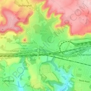
Navn: Topografisk kort Frogholt, højde, relief.
Gjennomsnittlig høyde: 93 m
Minste høyde: 13 m
Maksimal høyde: 188 m
Gi en donasjon
Andre topografiske kart
Klikk på et kart for å se dets topografi, dets høyde og dets relieff.
Stelling Minnis
United Kingdom > England > Kent > Folkestone and Hythe District
Gjennomsnittlig høyde: 135 m
Folkestone
United Kingdom > England > Kent > Folkestone and Hythe District
Gjennomsnittlig høyde: 62 m
Gi en donasjon
Newington
United Kingdom > England > Kent > Folkestone and Hythe District
Gjennomsnittlig høyde: 112 m
Gi en donasjon
Elmsted
United Kingdom > England > Kent > Folkestone and Hythe District > Lymbridge Green
Gjennomsnittlig høyde: 144 m
Gi en donasjon
Greatstone beach
United Kingdom > England > Kent > Folkestone and Hythe District > New Romney > Littlestone on Sea
Gjennomsnittlig høyde: 2 m
Paddlesworth
United Kingdom > England > Kent > Folkestone and Hythe District
Gjennomsnittlig høyde: 161 m
Gi en donasjon
St. Mary in the Marsh
United Kingdom > England > Kent > Folkestone and Hythe District
Gjennomsnittlig høyde: 2 m
Gi en donasjon
Gi en donasjon
Monks Horton
United Kingdom > England > Kent > Folkestone and Hythe District
Gjennomsnittlig høyde: 104 m
Folkestone
United Kingdom > England > Kent > Folkestone and Hythe District
Gjennomsnittlig høyde: 62 m
Gi en donasjon
Folkestone
United Kingdom > England > Kent > Folkestone and Hythe District
Gjennomsnittlig høyde: 62 m
Gi en donasjon
Newington
United Kingdom > England > Kent > Folkestone and Hythe District
Gjennomsnittlig høyde: 112 m
Folkestone
United Kingdom > England > Kent > Folkestone and Hythe District
Gjennomsnittlig høyde: 62 m
Gi en donasjon
Folkestone
United Kingdom > England > Kent > Folkestone and Hythe District
Gjennomsnittlig høyde: 62 m
Folkestone
United Kingdom > England > Kent > Folkestone and Hythe District
Gjennomsnittlig høyde: 62 m