
Gi en donasjon
Topografisk kart Mengwi
Klikk på kartet for å vise høyde.
Gi en donasjon
Om dette kartet
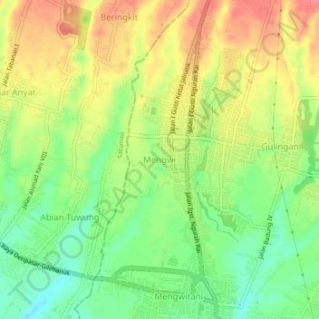
Navn: Topografisk kort Mengwi, højde, relief.
Sted: Mengwi, Badung, Bali, Lesser Sunda Islands, 08351, Indonesia (-8.56663 115.14650 -8.52663 115.18650)
Gjennomsnittlig høyde: 123 m
Minste høyde: 88 m
Maksimal høyde: 159 m
Gi en donasjon
Andre topografiske kart
Klikk på et kart for å se dets topografi, dets høyde og dets relieff.
Ayung River
The Ayung River watershed area has an annual average temperature between 18.4 °C and 26.6 °C, depending on the altitude. The average annual rainfall at the upstream is high, around 1963–3242 mm. Going downstream at an average inclination of 13.13%, the rainfall and the rainy days on the river decrease. In…
Gjennomsnittlig høyde: 444 m
Gi en donasjon
Pecatu
Pecatu is located in South Kuta District of the Badung Regency. It is at the western end of the Bukit Peninsula in south Bali, and has a hilly topography with limestone cliffs isolating small, short beaches that have been privately developed. Nusa Dua, on the opposite side of the peninsula, is flat and is a…
Gjennomsnittlig høyde: 65 m