
Gi en donasjon
Topografisk kart Montgomery Center
Klikk på kartet for å vise høyde.
Gi en donasjon
Om dette kartet
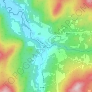
Navn: Topografisk kort Montgomery Center, højde, relief.
Gjennomsnittlig høyde: 269 m
Minste høyde: 143 m
Maksimal høyde: 487 m
Gi en donasjon
Andre topografiske kart
Klikk på et kart for å se dets topografi, dets høyde og dets relieff.
Fletcher
United States > Vermont > Franklin County
Fletcher is located in southern Franklin County, bordered to the southeast by Lamoille County. According to the United States Census Bureau, the town has a total area of 38.0 square miles (98.4 km2), of which 37.7 square miles (97.7 km2) is land and 0.3 square miles (0.7 km2), or 0.71%, is water. The Lamoille…
Gjennomsnittlig høyde: 229 m
Missisquoi River
United States > Vermont > Franklin County
The Missisquoi River rises in western Orleans County, Vermont, northwest of Lowell, Vermont, at an altitude of 247 metres (810 ft). This source is located next to Route 58 and adjacent to Belvidere Mountain. This source proves to be the continuity of the Burgess Branch (coming from the southwest).
Gjennomsnittlig høyde: 277 m
Gi en donasjon
Gi en donasjon
Fletcher
United States > Vermont > Franklin County
Fletcher is located in southern Franklin County, bordered to the southeast by Lamoille County. According to the United States Census Bureau, the town has a total area of 38.0 square miles (98.4 km2), of which 37.7 square miles (97.7 km2) is land and 0.3 square miles (0.7 km2), or 0.71%, is water. The Lamoille…
Gjennomsnittlig høyde: 229 m
Gi en donasjon