
Takk for at du støtter denne siden ❤️
Gi en donasjon
Gi en donasjon
Topografisk kart Cumberland Gap
Klikk på kartet for å vise høyde.
Takk for at du støtter denne siden ❤️
Gi en donasjon
Gi en donasjon
Cumberland Gap
The V-shaped gap serves as a gateway to the west. The base of the gap is about 300 ft (91 m) above the valley floor, even though the north side of the pass was lowered 20 ft (6.1 m) during the construction of Old U.S. Route 25E. To the south, the ridge rises 600 ft (180 m) above the pass, while to the north the Pinnacle Overlook towers 900 ft (270 m) above (elevation 2,505 ft (764 m)).
Takk for at du støtter denne siden ❤️
Gi en donasjon
Gi en donasjon
Om dette kartet
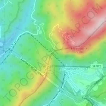
Navn: Topografisk kort Cumberland Gap, højde, relief.
Sted: Cumberland Gap, Lee County, Virginia, 37724, United States (36.60399 -83.67369 36.60409 -83.67359)
Gjennomsnittlig høyde: 512 m
Minste høyde: 349 m
Maksimal høyde: 783 m
Takk for at du støtter denne siden ❤️
Gi en donasjon
Gi en donasjon
Andre topografiske kart
Klikk på et kart for å se dets topografi, dets høyde og dets relieff.