
Takk for at du støtter denne siden ❤️
Gi en donasjon
Gi en donasjon
Topografisk kart Tai Po Tsai
Klikk på kartet for å vise høyde.
Takk for at du støtter denne siden ❤️
Gi en donasjon
Gi en donasjon
Om dette kartet
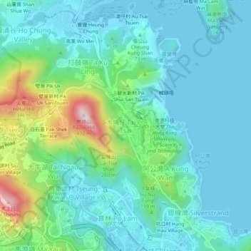
Navn: Topografisk kort Tai Po Tsai, højde, relief.
Gjennomsnittlig høyde: 85 m
Minste høyde: -5 m
Maksimal høyde: 407 m
Takk for at du støtter denne siden ❤️
Gi en donasjon
Gi en donasjon
Andre topografiske kart
Klikk på et kart for å se dets topografi, dets høyde og dets relieff.
Basalt Island
China > Hong Kong > Sai Kung District
Basalt Island is located south of Town Island and Wang Chau, east of Bluff Island and north of the Ninepin Group. Its highest elevation is 174 m. Notably, despite its name is “Basalt Island”, the rocks that forms the island are indeed rhyolitic tuff.
Gjennomsnittlig høyde: 6 m
Takk for at du støtter denne siden ❤️
Gi en donasjon
Gi en donasjon
Kiu Tsui Country Park
China > Hong Kong > Sai Kung District > Sai Kung > Kiu Tsui
Gjennomsnittlig høyde: 4 m
Takk for at du støtter denne siden ❤️
Gi en donasjon
Gi en donasjon