
Gi en donasjon
Topografisk kart Bellingham
Klikk på kartet for å vise høyde.
Gi en donasjon
Om dette kartet
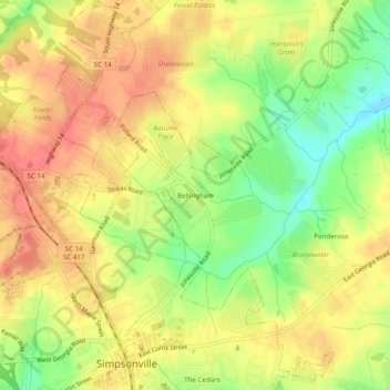
Navn: Topografisk kort Bellingham, højde, relief.
Gjennomsnittlig høyde: 259 m
Minste høyde: 223 m
Maksimal høyde: 284 m
Gi en donasjon
Andre topografiske kart
Klikk på et kart for å se dets topografi, dets høyde og dets relieff.
Greenville
United States > South Carolina > Greenville County
Greenville features a varied topography characterized by rolling hills and the nearby Blue Ridge Mountains. The city sits at an elevation of approximately 984 feet (300 meters) above sea level, with its landscape shaped significantly by the Reedy River, which flows through the heart of downtown, creating…
Gjennomsnittlig høyde: 290 m
Simpsonville
United States > South Carolina > Greenville County
Simpsonville is located in southeastern Greenville County at 34°44′0″N 82°15′36″W / 34.73333°N 82.26000°W / 34.73333; -82.26000 (34.733375, -82.260001), between Mauldin to the northwest and Fountain Inn to the southeast. The center of town has an elevation of 866 feet (264 m) above sea level.
Gjennomsnittlig høyde: 259 m
Gi en donasjon
Slater-Marietta
United States > South Carolina > Greenville County > Slater-Marietta
Gjennomsnittlig høyde: 325 m
Gi en donasjon
Mountain Bridge Wilderness Area
United States > South Carolina > Greenville County
Gjennomsnittlig høyde: 680 m
Gi en donasjon
Gi en donasjon
Taylors
United States > South Carolina > Greenville County > Colonial Hills
Gjennomsnittlig høyde: 281 m
Gi en donasjon
Five Forks
United States > South Carolina > Greenville County > Five Forks
Gjennomsnittlig høyde: 254 m
Gi en donasjon
Ashmore Heritage Preserve
United States > South Carolina > Greenville County
Gjennomsnittlig høyde: 464 m
Bald Rock Heritage Preserve
United States > South Carolina > Greenville County
Gjennomsnittlig høyde: 480 m
Gi en donasjon
Simpsonville
United States > South Carolina > Greenville County
Simpsonville is located in southeastern Greenville County at 34°44′0″N 82°15′36″W / 34.73333°N 82.26000°W / 34.73333; -82.26000 (34.733375, -82.260001), between Mauldin to the northwest and Fountain Inn to the southeast. The center of town has an elevation of 866 feet (264 m) above sea level.
Gjennomsnittlig høyde: 258 m
Gi en donasjon