
Gi en donasjon
Topografisk kart Lithia
Klikk på kartet for å vise høyde.
Gi en donasjon
Om dette kartet
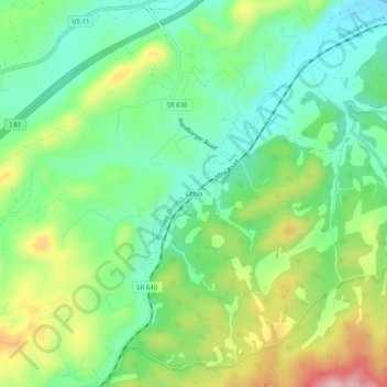
Navn: Topografisk kort Lithia, højde, relief.
Sted: Lithia, Botetourt County, Virginia, United States (37.45819 -79.77143 37.49819 -79.73143)
Gjennomsnittlig høyde: 342 m
Minste høyde: 265 m
Maksimal høyde: 483 m
Gi en donasjon
Andre topografiske kart
Klikk på et kart for å se dets topografi, dets høyde og dets relieff.
Blue Ridge Mountains
United States > Virginia > Botetourt County
Although the term "Blue Ridge" is sometimes applied exclusively to the eastern edge or front range of the Appalachian Mountains, the geological definition of the Blue Ridge province extends westward to the Ridge and Valley area, encompassing the Great Smoky Mountains, the Great Balsams, the Roans, the Blacks,…
Gjennomsnittlig høyde: 460 m
Gi en donasjon
Blue Ridge Mountains
United States > Virginia > Botetourt County
Although the term "Blue Ridge" is sometimes applied exclusively to the eastern edge or front range of the Appalachian Mountains, the geological definition of the Blue Ridge province extends westward to the Ridge and Valley area, encompassing the Great Smoky Mountains, the Great Balsams, the Roans, the Blacks,…
Gjennomsnittlig høyde: 461 m