
Gi en donasjon
Topografisk kart Fort William
Klikk på kartet for å vise høyde.
Gi en donasjon
Fort William
Fort William has an oceanic climate (Cfb) with moderate, but generally cool, temperatures and abundant precipitation. In the towns immediate vicinity, there are significant variations in elevation, which leads to some uninhabited areas near the town having a subpolar oceanic climate (Cfc), or, at the absolute highest elevations such as Ben Nevis, a tundra climate (ET). Fort William does not have an official MetOffice weather station; as such, the values in the table below are simulated, and the record high and low temperatures are not available.
Gi en donasjon
Om dette kartet
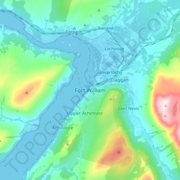
Navn: Topografisk kort Fort William, højde, relief.
Sted: Fort William, Highland, Scotland, PH33 6AQ, United Kingdom (56.77783 -5.15097 56.85783 -5.07097)
Gjennomsnittlig høyde: 122 m
Minste høyde: -2 m
Maksimal høyde: 704 m
Gi en donasjon
Andre topografiske kart
Klikk på et kart for å se dets topografi, dets høyde og dets relieff.