
Gi en donasjon
Topografisk kart Hogeye
Klikk på kartet for å vise høyde.
Gi en donasjon
Om dette kartet
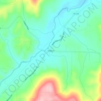
Navn: Topografisk kort Hogeye, højde, relief.
Sted: Hogeye, Washington County, Arkansas, United States (35.90036 -94.28771 35.94036 -94.24771)
Gjennomsnittlig høyde: 414 m
Minste høyde: 362 m
Maksimal høyde: 541 m
Gi en donasjon
Andre topografiske kart
Klikk på et kart for å se dets topografi, dets høyde og dets relieff.
Fayetteville
United States > Arkansas > Washington County
Fayetteville is nestled in the picturesque Ozark Mountains, characterized by rolling hills, lush forests, and scenic valleys that define the region's topography. The elevation in Fayetteville ranges from about 1,100 feet to over 1,500 feet above sea level, creating a varied landscape that features steep ridges…
Gjennomsnittlig høyde: 401 m
Greenland
United States > Arkansas > Washington County
The climate in this area is characterized by hot, extremely humid summers and generally cool to very cold winters depending on elevation. According to the Köppen Climate Classification system, Greenland has a humid subtropical climate, abbreviated "Cfa" on climate maps.
Gjennomsnittlig høyde: 419 m
Gi en donasjon
Gi en donasjon
Fayetteville
United States > Arkansas > Washington County
...yet I venture the assertion that nowhere in said country—or for that matter, in any part of the state—could be found a lovelier elevation, or a lovelier grove of graceful oaks, or a more commanding view, or, in fine, a spot better suited and adapted for the purposes designated than the one chosen for…
Gjennomsnittlig høyde: 401 m
West Fork
United States > Arkansas > Washington County
West Fork is located at 35°56′08″N 94°10′48″W / 35.93556°N 94.18000°W / 35.93556; -94.18000 (35.9356771, -94.1801038) at an elevation of 1,358 feet (414 m). According to the United States Census Bureau, the city has a total area of 3.3 square miles (8.5 km2), all land.
Gjennomsnittlig høyde: 468 m
Gi en donasjon