
Gi en donasjon
Topografisk kart South Hamilton
Klikk på kartet for å vise høyde.
Gi en donasjon
Om dette kartet
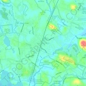
Navn: Topografisk kort South Hamilton, højde, relief.
Gjennomsnittlig høyde: 19 m
Minste høyde: 5 m
Maksimal høyde: 67 m
Gi en donasjon
Andre topografiske kart
Klikk på et kart for å se dets topografi, dets høyde og dets relieff.
Amesbury
United States > Massachusetts > Essex County
Amesbury is located at 42°51′29″N 70°55′50″W / 42.85806°N 70.93056°W / 42.85806; -70.93056. According to the United States Census Bureau, the city has a total area of 13.7 square miles (35.5 km2), of which 12.3 square miles (31.8 km2) is land and 1.5 square miles (3.8 km2), or 10.65%, is…
Gjennomsnittlig høyde: 25 m
Gi en donasjon
Gi en donasjon
Haverhill
United States > Massachusetts > Essex County
According to the United States Census Bureau, the city has a total area of 35.6 square miles (92.3 km2), of which 33.0 square miles (85.4 km2) is land and 2.7 square miles (6.9 km2), or 7.47%, is water. The city ranks 60th in the Commonwealth in terms of land area, and is the largest city or town in Essex…
Gjennomsnittlig høyde: 39 m
Gi en donasjon
Topsfield
United States > Massachusetts > Essex County
According to the United States Census Bureau, Topsfield has a total area of 12.8 square miles (33.2 km2), of which 11.9 square miles (30.9 km2) are land and 0.89 square miles (2.3 km2), or 7.00%, is water. Topsfield lies in the geographic center of Essex County, Massachusetts. Like its namesake in Essex,…
Gjennomsnittlig høyde: 24 m
Gi en donasjon
Gi en donasjon
Danvers
United States > Massachusetts > Essex County
Though being at sea level in the Danversport area, the town has numerous hills reaching around 130 to 180 feet in elevation, including Dales Hill (located at St. John's Preparatory School), Ferncroft Hill, Folly Hill, Hathorne Hill, Lindall Hill, Nichols Hill, Putnam Hill, Rocky Hill and Whipple Hill (part of…
Gjennomsnittlig høyde: 22 m
Boxford
United States > Massachusetts > Essex County
Boxford is divided into Boxford Village (commonly called East Boxford) and West Boxford Village, corresponding to the respective East and West Boxford centers. It is heavily forested and criss-crossed by various streams and brooks, many of which empty into the Ipswich River on Boxford's southern border. A…
Gjennomsnittlig høyde: 35 m
Gi en donasjon
Blackwater River
United States > Massachusetts > Essex County > Salisbury > Salisbury Beach
Gjennomsnittlig høyde: 4 m
Gi en donasjon
Danvers
United States > Massachusetts > Essex County
Though being at sea level in the Danversport area, the town has numerous hills reaching around 130 to 180 feet in elevation, including Dales Hill (located at St. John's Preparatory School), Ferncroft Hill, Folly Hill, Hathorne Hill, Lindall Hill, Nichols Hill, Putnam Hill, Rocky Hill and Whipple Hill (part of…
Gjennomsnittlig høyde: 23 m
Haverhill
United States > Massachusetts > Essex County
According to the United States Census Bureau, the city has a total area of 35.6 square miles (92.3 km2), of which 33.0 square miles (85.4 km2) is land and 2.7 square miles (6.9 km2), or 7.47%, is water. The city ranks 60th in the Commonwealth in terms of land area, and is the largest city or town in Essex…
Gjennomsnittlig høyde: 39 m
Gi en donasjon
Gi en donasjon
Gi en donasjon
Ipswitch Great Flats
United States > Massachusetts > Essex County > Ipswich
Gjennomsnittlig høyde: 1 m
Topsfield
United States > Massachusetts > Essex County
According to the United States Census Bureau, Topsfield has a total area of 12.8 square miles (33.2 km2), of which 11.9 square miles (30.9 km2) are land and 0.89 square miles (2.3 km2), or 7.00%, is water. Topsfield lies in the geographic center of Essex County, Massachusetts. Like its namesake in Essex,…
Gjennomsnittlig høyde: 25 m
Gi en donasjon
Amesbury
United States > Massachusetts > Essex County
Amesbury is located at 42°51′29″N 70°55′50″W / 42.85806°N 70.93056°W / 42.85806; -70.93056. According to the United States Census Bureau, the city has a total area of 13.7 square miles (35.5 km2), of which 12.3 square miles (31.8 km2) is land and 1.5 square miles (3.8 km2), or 10.65%, is…
Gjennomsnittlig høyde: 25 m
Gi en donasjon
Haverhill
United States > Massachusetts > Essex County
According to the United States Census Bureau, the city has a total area of 35.6 square miles (92.3 km2), of which 33.0 square miles (85.4 km2) is land and 2.7 square miles (6.9 km2), or 7.47%, is water. The city ranks 60th in the Commonwealth in terms of land area, and is the largest city or town in Essex…
Gjennomsnittlig høyde: 39 m
Gi en donasjon
Eastern Point Light
United States > Massachusetts > Essex County > Gloucester
Gjennomsnittlig høyde: 1 m
Kings Beach
United States > Massachusetts > Essex County > Lynn > East Lynn
Gjennomsnittlig høyde: 9 m
Gi en donasjon
Hamilton
United States > Massachusetts > Essex County
According to the United States Census Bureau, the town has a total area of 14.9 square miles (38.6 km2), of which 14.2 square miles (36.7 km2) is land and 0.73 square miles (1.9 km2), or 4.89%, is water. Hamilton lies 5 miles (8 km) inland from Massachusetts Bay, and both the eastern and western portion of…
Gjennomsnittlig høyde: 19 m
Gi en donasjon
Boxford
United States > Massachusetts > Essex County
Boxford is divided into Boxford Village (commonly called East Boxford) and West Boxford Village, corresponding to the respective East and West Boxford centers. It is heavily forested and criss-crossed by various streams and brooks, many of which empty into the Ipswich River on Boxford's southern border. A…
Gjennomsnittlig høyde: 35 m
Gi en donasjon
Gi en donasjon