
Gi en donasjon
Topografisk kart Neale Place
Klikk på kartet for å vise høyde.
Gi en donasjon
Om dette kartet
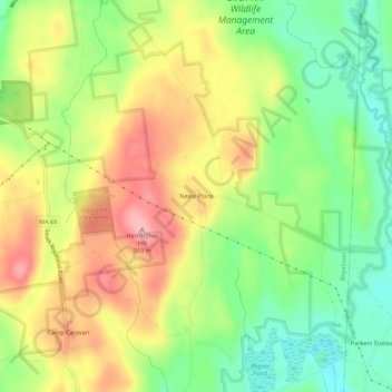
Navn: Topografisk kort Neale Place, højde, relief.
Gjennomsnittlig høyde: 300 m
Minste høyde: 240 m
Maksimal høyde: 366 m
Gi en donasjon
Andre topografiske kart
Klikk på et kart for å se dets topografi, dets høyde og dets relieff.
Worcester
United States > Massachusetts > Worcester County
Worcester is known for being particularly snowy in the cold months, sometimes even experiencing autumn blizzards. The city averages 48.1 inches (1,220 mm) of precipitation a year, as well as an average of 72.9 inches (185 cm) of snowfall a season, receiving far more snow than coastal locations less than 40…
Gjennomsnittlig høyde: 186 m
Gardner
United States > Massachusetts > Worcester County
According to the United States Census Bureau, Gardner has a total area of 23.0 square miles (60 km2), of which 22.2 square miles (57 km2) is land and 0.8 square miles (2.1 km2), or 3.52%, is water. The city is situated on Crystal Lake. Its highest point is the summit of Reservoir Hill, close to the city…
Gjennomsnittlig høyde: 326 m
Gi en donasjon
Gi en donasjon
Harvard
United States > Massachusetts > Worcester County
The eastern part of Harvard is on a large ridgeline. In 1931 Harvard College established the Oak Ridge Observatory at an elevation of 609 feet on Pinnacle Rd, the highest point between Mount Wachusett and the ocean.
Gjennomsnittlig høyde: 100 m
Gi en donasjon
Westborough
United States > Massachusetts > Worcester County
According to the United States Census Bureau, the town has a total area of 21.6 square miles (56.0 km2), of which 20.5 square miles (53.1 km2) of it is land, and 1.1 square miles (2.8 km2) of it is water or 5.09 percent. Westborough contains the headwaters of the Sudbury and Assabet rivers. The town contains…
Gjennomsnittlig høyde: 113 m
Gi en donasjon
Gi en donasjon
Beaver Brook
United States > Massachusetts > Worcester County > Templeton
Gjennomsnittlig høyde: 302 m
Gi en donasjon
Gi en donasjon
Uxbridge
United States > Massachusetts > Worcester County
The town is 30.4 square miles (79 km2), of which 0.8 square miles (2.1 km2), or 2.74%, is water. It is situated 39.77 miles (64.00 km) southwest of Boston, 16 miles (26 km) southeast of Worcester, and 20 miles (32 km) northwest of Providence. Elevations range from 200 feet (61 m) to 577 feet (176 m) above sea…
Gjennomsnittlig høyde: 116 m
Gi en donasjon
Athol
United States > Massachusetts > Worcester County
According to the United States Census Bureau, the town has a total area of 33.4 square miles (86.5 km2), of which 32.6 square miles (84.4 km2) is land and 0.8 square miles (2.1 km2) (2.46%) is water. The town is drained mostly by the Millers River, which flows through the downtown area from northeast to west,…
Gjennomsnittlig høyde: 251 m
Douglas
United States > Massachusetts > Worcester County
The principal elevations are Bald Hill, 711 feet (217 m), Wallum Pond Hill, 778 feet (237 m), Mount Ashworth, 713 feet (218 m), and Mount Daniel, 735 feet (224 m). There are numerous ponds in Douglas: Wallum Pond in the southwestern section, covering approximately 150 acres (61 ha); Badluck Pond in the western…
Gjennomsnittlig høyde: 173 m
Gi en donasjon
Ashburnham
United States > Massachusetts > Worcester County
According to the United States Census Bureau, the town has a total area of 41.0 square miles (106 km2), of which 38.7 square miles (100 km2) is land and 2.3 square miles (6.0 km2) (5.68%) is water. Ashburnham has two distinct topographical areas, hilly to the east and relatively flat high ground to the west.…
Gjennomsnittlig høyde: 345 m
Gi en donasjon
Gi en donasjon
Gi en donasjon
Gi en donasjon
Crow Hill Ledges
United States > Massachusetts > Worcester County > Westminster
Gjennomsnittlig høyde: 293 m
Gi en donasjon
Hadwen Park
United States > Massachusetts > Worcester County > Worcester > Heard Street
Gjennomsnittlig høyde: 166 m
Worcester
United States > Massachusetts > Worcester County
Worcester is known for being particularly snowy in the cold months, sometimes even experiencing intense autumn blizzards. The city averages 48.07 inches (1,220 mm) of precipitation a year, as well as an average of 64 inches (160 cm) of snowfall a season, receiving far more snow than coastal locations less than…
Gjennomsnittlig høyde: 186 m
Athol
United States > Massachusetts > Worcester County
According to the United States Census Bureau, the town has a total area of 33.4 square miles (86.5 km2), of which 32.6 square miles (84.4 km2) is land and 0.8 square miles (2.1 km2) (2.46%) is water. The town is drained mostly by the Millers River, which flows through the downtown area from northeast to west,…
Gjennomsnittlig høyde: 256 m
Gi en donasjon
Institute Park
United States > Massachusetts > Worcester County > Worcester > Belmont Hill
Gjennomsnittlig høyde: 170 m
Gi en donasjon
Gardner
United States > Massachusetts > Worcester County
According to the United States Census Bureau, Gardner has a total area of 23.0 square miles (60 km2), of which 22.2 square miles (57 km2) is land and 0.8 square miles (2.1 km2), or 3.52%, is water. The city is situated on Crystal Lake. Its highest point is the summit of Reservoir Hill, close to the city…
Gjennomsnittlig høyde: 326 m
Thompsons Pond Dam
United States > Massachusetts > Worcester County > Spencer
Gjennomsnittlig høyde: 278 m
Gi en donasjon
Gi en donasjon
Westborough
United States > Massachusetts > Worcester County
According to the United States Census Bureau, the town has a total area of 21.6 square miles (56.0 km2), of which 20.5 square miles (53.1 km2) of it is land, and 1.1 square miles (2.8 km2) of it is water or 5.09 percent. Westborough contains the headwaters of the Sudbury and Assabet rivers. The town contains…
Gjennomsnittlig høyde: 113 m
Gi en donasjon
Gi en donasjon
Uxbridge
United States > Massachusetts > Worcester County
The town is 30.4 square miles (79 km2), of which 0.8 square miles (2.1 km2), or 2.74%, is water. It is situated 39.77 miles (64.00 km) southwest of Boston, 16 miles (26 km) southeast of Worcester, and 20 miles (32 km) northwest of Providence. Elevations range from 200 feet (61 m) to 577 feet (176 m) above sea…
Gjennomsnittlig høyde: 115 m
Gi en donasjon
Lake Ellis
United States > Massachusetts > Worcester County > Athol > The Street
Gjennomsnittlig høyde: 281 m
Gi en donasjon
Big Alum Lake
United States > Massachusetts > Worcester County > Sturbridge
Gjennomsnittlig høyde: 227 m
Gi en donasjon
Gi en donasjon