
Gi en donasjon
Topografisk kart Deep Creek Gap
Klikk på kartet for å vise høyde.
Gi en donasjon
Om dette kartet
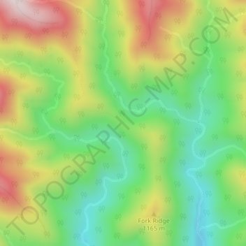
Navn: Topografisk kort Deep Creek Gap, højde, relief.
Sted: Deep Creek Gap, Swain County, North Carolina, United States (35.55872 -83.42287 35.55882 -83.42277)
Gjennomsnittlig høyde: 1 034 m
Minste høyde: 816 m
Maksimal høyde: 1 340 m
Gi en donasjon
Andre topografiske kart
Klikk på et kart for å se dets topografi, dets høyde og dets relieff.
Fontana Dam
United States > North Carolina > Swain County
Fontana Dam is 2,365 feet (721 m) long and 480 feet (146 m) high, making it the tallest dam in the Eastern United States. The dam has a flood storage capacity of 513,965 acre-feet (633,966,000 m3), and the combined capacity of its three generators is 293.6 megawatts. Fontana Lake has 238 miles (383 km) of…
Gjennomsnittlig høyde: 525 m
Fontana Lake
United States > North Carolina > Swain County
Fontana Lake provides the only access into the most remote areas of the National Park, unless visitors undertake a multi-day hike to get there. When the lake is at the normal summer level, a boat may be used to access remote trailheads such as Hazel Creek. From the observation tower on Kuwohi, on a clear day…
Gjennomsnittlig høyde: 806 m
Gi en donasjon