
Gi en donasjon
Topografisk kart Traquair
Klikk på kartet for å vise høyde.
Gi en donasjon
Om dette kartet
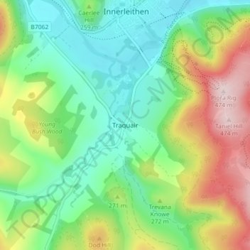
Navn: Topografisk kort Traquair, højde, relief.
Sted: Traquair, Scottish Borders, Scotland, EH44 6PJ, United Kingdom (55.58090 -3.08364 55.62090 -3.04364)
Gjennomsnittlig høyde: 247 m
Minste høyde: 128 m
Maksimal høyde: 470 m
Gi en donasjon
Andre topografiske kart
Klikk på et kart for å se dets topografi, dets høyde og dets relieff.
Gi en donasjon
Greenknowe Tower
United Kingdom > Scotland > Scottish Borders > Gordon > Nether Huntlywood
Gjennomsnittlig høyde: 157 m
Gi en donasjon
Gi en donasjon
Moffat Hills
United Kingdom > Scotland > Scottish Borders > Tweedsmuir
The Megget Stane (OS. Ref. NT152203) is by a cattle grid at the highest point between the Talla and Megget reservoirs on the minor road which runs from Tweedsmuir on the A701 to Cappercleuch by shore of St Mary's Loch. It is quite easy to miss the stone when coming from Talla as it is hidden by a gate. At an…
Gjennomsnittlig høyde: 430 m
Curling Pond
United Kingdom > Scotland > Scottish Borders > Earlston > Georgefield
Gjennomsnittlig høyde: 153 m
Hirsel Lake
United Kingdom > Scotland > Scottish Borders > Coldstream > The Hirsel
Gjennomsnittlig høyde: 37 m
Gi en donasjon