
Takk for at du støtter denne siden ❤️
Gi en donasjon
Gi en donasjon
Topografisk kart Dhemaji
Klikk på kartet for å vise høyde.
Takk for at du støtter denne siden ❤️
Gi en donasjon
Gi en donasjon
Dhemaji
Dhemaji is located at 27°29′N 94°35′E / 27.48°N 94.58°E / 27.48; 94.58. It has an average elevation of 91 metres (298 feet). Dhemaji is located to the north of the river Brahmaputra. To its north lies the Arunachal Himalayas. To its east lies the state, Arunachal Pradesh and to the west is Lakhimpur, a district of Assam. It has many large and small rivers flowing through it. Some of them are Jiadhal, Gainodi, Dikhari, Dihang, Dimow and Simen. The Subansiri River flows by its western border.
Takk for at du støtter denne siden ❤️
Gi en donasjon
Gi en donasjon
Om dette kartet
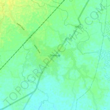
Navn: Topografisk kort Dhemaji, højde, relief.
Sted: Dhemaji, Assam, 787057, India (27.43638 94.52296 27.51638 94.60296)
Gjennomsnittlig høyde: 102 m
Minste høyde: 95 m
Maksimal høyde: 112 m
Takk for at du støtter denne siden ❤️
Gi en donasjon
Gi en donasjon