
Gi en donasjon
Topografisk kart Kjerag
Klikk på kartet for å vise høyde.
Gi en donasjon
Om dette kartet
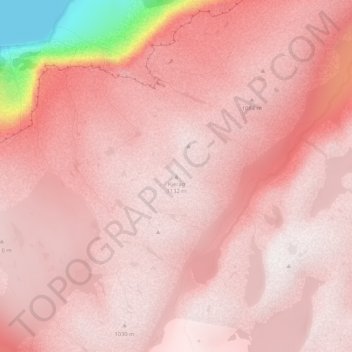
Navn: Topografisk kort Kjerag, højde, relief.
Sted: Kjerag, Sandnes, Rogaland, Norway (59.02627 6.59563 59.02637 6.59573)
Gjennomsnittlig høyde: 970 m
Minste høyde: 0 m
Maksimal høyde: 1 162 m
Gi en donasjon
Andre topografiske kart
Klikk på et kart for å se dets topografi, dets høyde og dets relieff.
Gi en donasjon
Gi en donasjon
Gi en donasjon
Gi en donasjon
Gi en donasjon
Stavanger
The municipality of Stavanger is located in a coastal landscape, bordering the sea to the west and Boknafjorden in the northeast. The Byfjorden and Gandsfjorden run along the east side of the city. It is part of the Low-Jæren, a flat area of land consisting mostly of marsh, sand, and stone aur, that ranges…
Gjennomsnittlig høyde: 42 m
Gi en donasjon
Stavanger
The municipality of Stavanger is located in a coastal landscape, bordering the sea to the west and Boknafjorden in the northeast. The Byfjorden and Gandsfjorden run along the east side of the city. It is part of the Low-Jæren, a flat area of land consisting mostly of marsh, sand, and stone aur, that ranges…
Gjennomsnittlig høyde: 37 m
Gi en donasjon
Stavanger
The municipality of Stavanger is located in a coastal landscape, bordering the sea to the west and Boknafjorden in the northeast. The Byfjorden and Gandsfjorden run along the east side of the city. It is part of the Low-Jæren, a flat area of land consisting mostly of marsh, sand, and stone aur, that ranges…
Gjennomsnittlig høyde: 42 m
Gi en donasjon